kingaucho
Well-Known Member
I read somewhere that only 3 cabins survived this fire. Can’t guarantee it true thoughDoes anyone know if the remaining few cabins in Holy Jim Canyon burned?
Last edited:
I read somewhere that only 3 cabins survived this fire. Can’t guarantee it true thoughDoes anyone know if the remaining few cabins in Holy Jim Canyon burned?
")


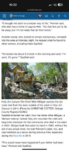
") Holy Jim Canyon Fire Chief Mike Milligan surveys the dry creek bed from the deck outside of his cabin in Holy Jim Canyon in 2014. (Photo by CHRISTINE COTTER, Orange County Register/SCNG)
Holy Jim Canyon Fire Chief Mike Milligan surveys the dry creek bed from the deck outside of his cabin in Holy Jim Canyon in 2014. (Photo by CHRISTINE COTTER, Orange County Register/SCNG)")


I took my daughter and her BF up there two weeks ago on the way back down from hiking Castle Rock trail.Keller Peak Fire Lookout before and after. Pics are 2 months apart. Damn Shame.
Built in 1926. Almost made it 100 years.
axxording to the perimeter map it definitely crossed the lower end of Explo, But Evdog is right quite possible just burned a little ground cover. When they actually reopen the trail-who knows. but at least the whole thing didnt get torched.Hoping for soon i love that trail and i regret not hiotting it this summer. I was nervous about Bluff Lake-wife and I's favorite spot to go hike or just chill in the forest by a lake, often part of a hike of the nearby section of Skyline or Siberia Creek., Looks like its safe, hope they dont simply close that whole area for years,, seems unlikelyI know it's petty in the scheme of things, but I'm really hoping that Exploration Trail made it. Looking at Cal Fire's map, it looks like maybe only the top parking area got hit, but that's all:
View attachment 94854
Same to be said about the Post Office Loop of the SART. I'm sure it will be closed off, but looks like it hasn't been hit. Thomas Hunting Grounds and lower portions are gone though.
View attachment 94855
Airport fire still going, no growth in total size, containment is up to 39%.
Saw a report that 160+ structures have been lost. I know most of the Trabucon/Holy Jim cabins are gone. Heard about some loss in the El Cariso area, are there even 150+ structures there?
Anybody heard any more details of what burned where?
Eerily prophetic @mtnbikej, turns out the plan is to effectively close the entire f@cking forest and do nothing for at least a year. Can't believe the useless cunts at the forest service can even get away with this.The plan, is to close the burn effected are for the first rainy season. Done we are already into Sept. and it won’t be extinguished until at least November….they will say that this rainy season doesn’t count m….keeping everything closed for another year.
In those 2 years, they will do nothing. They will not attempt to mitigate the rain/run off. They will not attempt to rehabilitate the area. Then 2 years from now, they will start to maybe think about what to do. That will take an additional 2 years.
we just spent the last year beginning the rehabilitation of Trabuco Trail from the 2018 Holy Fire.
So to answer your question….no they are aren’t planning.
Sounds like a massive class action lawsuit about to be filed against the OC public works. Nothing like suing yourself...
It is very frustrating that STT and Luge are off limits for a year.
I read something that said they're going to "periodically evaluate" the non-burn areas, so I doubt Luge will be closed for long. Plus, nobody is going to respect a ridiculous closure.Thres no reason to close anywhere north of 4 corners,, or the stt/luge loop,, or south of morgan trail in san mateo, Cant even hike in san mateo wilderness starting at the south trailhead? Just crazy, OC parks are going to get worked by all the extra usage,
if Laguna or other oc parks burn too almost all outdoor recreation without using a whole tank of gas will be unattainable for OC folks,
Also, good luck keeping evryone out for a year with what 2 rangers? I am normally one who abides by all the rules but thats getting difficult,
Also now theres nowhere to ride or hike nearby when its raining,, Guess ill be driving more
This is what I would expect especially with the pressure they are going to get to reopen unaffected areas.I read something that said they're going to "periodically evaluate" the non-burn areas, so I doubt Luge will be closed for long. Plus, nobody is going to respect a ridiculous closure.
Utterly bizarre that unaffected areas would be closed at all. I fully get not riding burn areas, but yeah, even if it's closed ... not going to deter many OC types. It will probably keep the half-girly L.A. types away, so ... Win.This is what I would expect especially with the pressure they are going to get to reopen unaffected areas.
hope this is the case,I read something that said they're going to "periodically evaluate" the non-burn areas, so I doubt Luge will be closed for long. Plus, nobody is going to respect a ridiculous closure.
hope this is the case,
Wolnder how draconian the closures in SBNF and ANF will be