You are using an out of date browser. It may not display this or other websites correctly.
You should upgrade or use an alternative browser.
You should upgrade or use an alternative browser.
Fire Season Stuff
- Thread starter Runs with Scissors
- Start date
Runs with Scissors
iMTB Hooligan
I hope our bureaucracy is already working on the plan.
I admire your optimism.

DangerDirtyD
iMTB Hooligan
Derkderkall
iMTB Rockstah
It's been 4 years since the Bobcat fire tore through our local mountains... many of the trails and areas have not yet opened. They will open soon, but mostly thanks to volunteer groups like Lowelifes and San Gab Trail builders....I admire your optimism.
Municipality of Monrovia is actively working to re-open the canyon park trails.. but thats small scale and local. Arcadia nature center is still closed....
So... yeah.. definitely don't hold your breath..
mtnbikej
J-Zilla
I hope our bureaucracy is already working on the plan.
The plan, is to close the burn effected are for the first rainy season. Done we are already into Sept. and it won’t be extinguished until at least November….they will say that this rainy season doesn’t count m….keeping everything closed for another year.
In those 2 years, they will do nothing. They will not attempt to mitigate the rain/run off. They will not attempt to rehabilitate the area. Then 2 years from now, they will start to maybe think about what to do. That will take an additional 2 years.
we just spent the last year beginning the rehabilitation of Trabuco Trail from the 2018 Holy Fire.
So to answer your question….no they are aren’t planning.
mtnbikej
J-Zilla
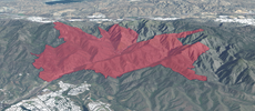
Based on the mapping, Lower HJ is gone mostly. Bell Ridge almost all the way. Los Pinos is being hit about 2/3rds right now….and expanding. Bottom Of Trabuco Trail has been hit again.
Per radio traffic and the cameras at Santiago Peak, Joplin may very well be on the chopping block.
San Juan is not safe either.
Per radio traffic and the cameras at Santiago Peak, Joplin may very well be on the chopping block.
San Juan is not safe either.
Lost Kiwi
Well-Known Member
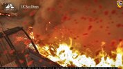
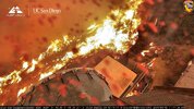
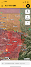
Just flared up in the last hour on our side. I think we're just about to lose Joplin, sorry for the crappy pic but its pushing round under Santiago right now and moving towards Modjeska.
Ortega Highway has just been closed as well. It looks like its less than 8000 feet from Lazy W and San Juan trailhead

Ortega Highway has just been closed as well. It looks like its less than 8000 feet from Lazy W and San Juan trailhead
Lost Kiwi
Well-Known Member
Took less than 20 minutes to reach Modjeska. At least some of Joplin has got to have been hit.Just flared up in the last hour on our side. I think we're just about to lose Joplin, sorry for the crappy pic but its pushing round under Santiago right now and moving towards Modjeska.
Ortega Highway has just been closed as well. It looks like its less than 8000 feet from Lazy W and San Juan trailhead
View attachment 94813
Old&InTheWay
Well-Known Member

Runs with Scissors
iMTB Hooligan
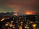
Bad, but not extinction level - this is as of 1254, about a minute ago.

Tom the Bomb
iMTB Rockstah
The air quality in Fallbrook is bad today. My allergies are acting up and the particulates are making me hoarse with sore throat. Staying inside. Hoping to ride Thurs.They're holding it below Running Springs, but now it's burning east across the SBNF towards Seven Oaks Dam, Alder Creek, Keller Creek, etc. Constance Peak, Seven Oaks, Angelus Oaks, Santa Ana watershed are all at risk. I really thought this would get knocked down as there are no winds to speak of, but it got out of hand and is now creating it's own. Monsoonal rains yesterday and potentially again today will help. Air in the eastern SB valley is terrible, I'm not sure how far inland it's getting.
Line Fire | CAL FIRE
www.fire.ca.gov
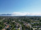
Friday afternoon when things were just kinda' bad, not awful:

Last edited:
Tom the Bomb
iMTB Rockstah
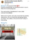
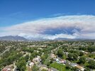
I guess Monroe TT is gone?Lots of ash on the car this morning and orange skies over the eastern san gabes. The bridge fire is burning between Glendora mountain road and Glendora ridge road.
Y-not
iMTB Rockstah
Come on up to Bass Lake and ride 007 this Friday and Goat Mountain on Saturday.....The air quality in Fallbrook is bad today. My allergies are acting up and the particulates are making me hoarse with sore throat. Staying inside. hoping to ride Thurs.
DangerDirtyD
iMTB Hooligan
Monroe TT is still there for now. The fire started about 2.3 miles east of MTT and is generally moving away from MTT. However, Sunset Peak Mountain Way is in danger.I guess Monroe TT is gone?
Obsidian
iMTB Rockstah
Oddly enough, no smoke smell yet at my place. The wind must be blowing the smoke away from me, but I know it is eventually coming.
I have a perfect view of the peak from my bedroom window and it looks gnarly. Mostly just massive clouds of smoke, but right now I can see the fire, which is pretty wild in the middle of the day and considering how far away it is from here.
I have a perfect view of the peak from my bedroom window and it looks gnarly. Mostly just massive clouds of smoke, but right now I can see the fire, which is pretty wild in the middle of the day and considering how far away it is from here.
DangerDirtyD
iMTB Hooligan
I think about all the wildlife scorched with the earth or fleeing to urban environs.Oddly enough, no smoke smell yet at my place. The wind must be blowing the smoke away from me, but I know it is eventually coming.
I have a perfect view of the peak from my bedroom window and it looks gnarly. Mostly just massive clouds of smoke, but right now I can see the fire, which is pretty wild in the middle of the day and considering how far away it is from here.
blixet
iMTB Rockstah
You got it!Come on up to Bass Lake and ride 007 this Friday and Goat Mountain on Saturday.....
Derkderkall
iMTB Rockstah
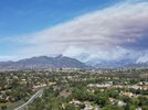
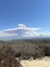
Driving east through Pasadena

Derkderkall
iMTB Rockstah
Can’t really see in the photo but that’s the south east end, another fast growing plume on the north west end…Driving east through PasadenaView attachment 94828
Derkderkall
iMTB Rockstah
I imagine East fork picnic area and bridge to nowhere, icehouse canyon are all in the zoneMonroe TT is still there for now. The fire started about 2.3 miles east of MTT and is generally moving away from MTT. However, Sunset Peak Mountain Way is in danger.
Derkderkall
iMTB Rockstah
DangerDirtyD
iMTB Hooligan
We can move it to the Laguna Mountains (for now)...?Might have to rethink that wrightwood outing